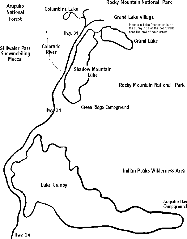
The Grand Lake area is well shown on maps of Colorado, USA. Check most any Colorado
map and look for the enlarged inset which is given for Rocky Mountain National Park. In the
southwest portion of the Park map, you'll find Grand Lake, Shadow Mountain Lake, and
Lake Granby. The National Park has a scenic road (Hwy. 34) which is the longest continuous
high tundra road in the continental USA. It connects Grand Lake to Estes Park on the east side
of the Continental Divide. The high tundra section of this paved road a not open in the winter.
Its snow accumulation is so great that the road is open only from about the end of May to
mid-October. Call us at 970-627-3103 for road conditions or check our Weather Report.
 People come to Grand Lake by driving through Rocky Mountain National
Park or by the year-round route up Hwy. 34 from the south. Either way,
the drive is very scenic. Hwy. 34 ends at Hwy. 40 near Granby, 15 miles
south of Grand Lake. Hwy. 40 used to be the westward route to Denver,
Colorado, and through the mountains to Salt Lake City and points beyond.
Most of the east-west traffic through Colorado now runs on Interstate 70.
To get to Grand Lake, you leave the traffic behind by turning off Interstate 70.
The Interstate 70 exit is well marked with signs pointing the way to Hwy. 40,
Rocky Mountain National Park, the Winter Park Ski area and the town of Empire,
which is very close to the exit. You leave busy Interstate 70 and soar to the top
of the Continental Divide at Berthoud Pass (11,307 feet, 3447 meters).
You then slowly descend through the heavily snowed upon headwaters of the Fraser River.
At the floor of the valley you'll soon meet the Mary Jane and Winter Park Ski areas. After
you pass through the town of Winter Park, the valley opens up, yet remains surrounded by
mountains. In a few minutes you'll pass through Fraser and Tabernash, then climb a hill
(close to the Pole Creek Golf Course), and continue past the YMCA of the Rockies,
SilverCreek Ski area and soon be in Granby. At the west end of Granby, you'll see where
to you turn onto Hwy. 34 and head towards Grand Lake and Rocky Mountain National Park.
You drive past ranches then climb a hill, and behold, there is Lake Granby with the
Continental Divide rising at its shore!
Below this map, Hwy 34 continues for about 5 miles until it ends at Hwy. 40 near Granby.
From Granby, Winter Park is just 20 minutes away!
For high quality maps visit these sites: (use your Back Button to return here)
Map of Colorado highlighting Grand County. Zoom in on Grand County.
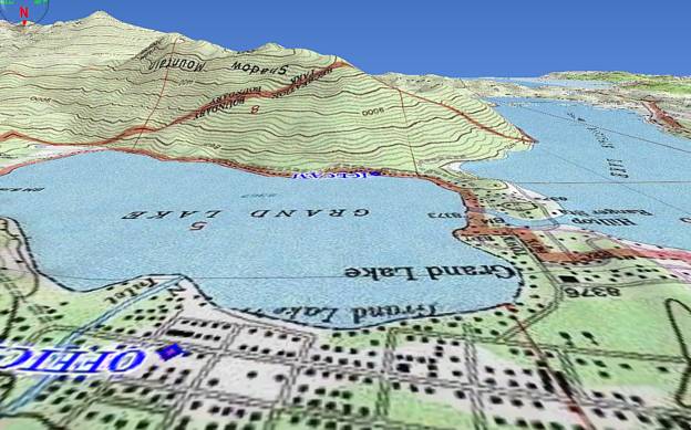
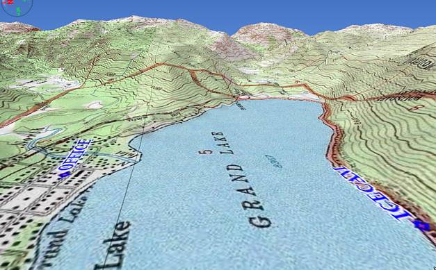
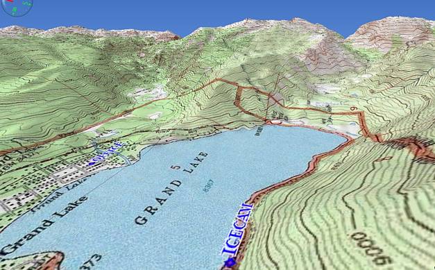
Grand Lake, Shadow Mountain Lake and Lake Granby form the Great Lakes of the Rockies.
Grand Lake is the largest natural lake in Colorado. A large portion of the lake is deeper than
250 feet (76 meters). Grand Lake has a surface area of 600 acres (243 hectares) at an
elevation of 8369 feet (2551 meters).
Lake Granby is a large reservoir collecting water from an enormous watershed rimmed by the
Continental Divide. Engineering projects have further increased the size of the lake's basin.
Snowmelt from as far away as Berthoud Pass near Winter Park can make it into Lake Granby
via the Windy Gap pump station just west of Granby. Streams from the Willow Creek Pass area
up Hwy. 125 flow into Willow Creek Reservoir. Its water is then pumped up to Lake Granby.
Lake Granby has a massive pump station at its northern end which lifts water from Lake Granby
to a canal (aka the fishing canal) which flows into Shadow Mountain Lake and then through a
channel to Grand Lake. The water can then make a remarkable journey through an immense tunnel
that runs all of the way under Rocky Mountain National Park and the Continental Divide to
Estes Park! The water then runs downhill through the foot hills of the Rockies to the Great Plains
of the USA!
The maximum surface area of Lake Granby is 7260 acres (2940 hectares). This year Lake Granby
will be almost full for most of the summer. The water near Granby Dam will be over 200 feet (60 meters)
deep! During dry years, the lake surface may drop 40 feet; leaving half of the lake still over 60 feet deep.
Shadow Mountain Lake is shallow except where it covers the original stream from Grand Lake and also
where it covers the North Fork of the Colorado River. The lake covers 1800 acres (730 hectares).
Additional maps will provided later. When you come in our office, we will give you
detailed maps and instructions for you to explore our wonderful area on your own.
Amtrak train service will take you directly to Fraser or Granby Colorado. The Denver to
Fraser route has many tunnels, including the 6.2 mile Moffat Tunnel under the Continental Divide.
Call Amtrak USA for schedule and prices. A special SKI TRAIN used to run Saturdays and Sundays
from Union Station in Denver to the base of the Winter Park Ski area. Hopefully it will come back.
.. to Main Menu
© Text & Structure of this site is Copyrighted 5/1/96.
var gaJsHost = (("https:" == document.location.protocol) ? "https://ssl." : "http://www."); document.write(unescape("%3Cscript src='" + gaJsHost + "google-analytics.com/ga.js' type='text/javascript'%3E%3C/script%3E")); try { var pageTracker = _gat._getTracker("UA-11272212-1"); pageTracker._trackPageview(); } catch(err) {}