 Click on photo to begin
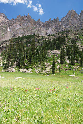
the journey to Caribou Lake, Coyote Park and Wheeler Basin.
We went there and back in a day, starting from near Meadow Creek
Reservoir. Deteriorating trail conditions and weather can make this
not possible. On the Monarch Lake quadrangle, Wheeler Basin is
indicated below the north slopes of North Arapaho Peak. It is a stunning
inner mountain basin tightly rimmed by towering peaks intricately carved
and eroded to create hundreds of figurines looking down upon travelers.
The high peaks in this remote area have names
like Arapaho, Arikaree, Navajo, Apache and George.
George is named after a white man who was a professor of geology in
Boulder and Colorado's state geologist from about 1907 to 1927.
The Wheeler of Wheeler Basin was also from Boulder and of George's era.
He explored every aspect of the basin that bears his name. High up in the
permanent snows, there is a W draw in white along the rim. With the help
of a few mountaineering and prospecting friends and hardy horses, Wheeler
privately created the very long Arapaho Pass trail that ascends from the
4th of July mine on the Boulder side to Arapaho Pass and then does many
switchbacks designed for pack trains of mules.
Wheeler also worked in the Silver Lakes region below Arapaho Glacier
that is now protected watershed for Boulder and from which Boulder gets
its claim as the only glacial water fed city.
From the turn of the century to the end of the 1930s, the lines were blurred
as to what is government work, what is civil service work and what
is private initiative.
The Arapaho trail is no ordinary trail. It was carved out with hard labor,
by horses, miners, explorers and naturalists. It was envisioned as being
the basis for a road for pack animals and soon automobiles to open up
the vast and fertile lands on the west side of the Continental Divide at the
headwaters of the Colorado River. Wheeler's trail blazing and maintenance
continued all the way down the west side of Arapaho Pass to Monarch Lake
in Grand County. It was envisioned that the gradual descent along
Arapaho Creek would be a favorable route for a road from Boulder to
the verdant promise lands that lay over and beyond the Continental Divide.
Below the tedious switchbacks on the west side of Arapaho Pass,
and just below picturesque Coyote Park, Wheeler blazed a trail
wrapping around the contours of Arapaho Peak's gigantic
steps and avoiding its many cliffs. This path sends one ever deeper
into what is now called the Indian Peaks Wilderness. With every step
as one follows this path (now invisible), one feels drawn ever further
away from civilization. As one winds around the unseen portions of
Arapaho Peak, it is like journeying deep into the secrets of a nautilus shell
of mountainous proportions.
The alpine meadow that lies at the end, Wheeler named "Garden of the Pinnacles."
This much I have learned from a few of Wheeler's heirs.
Early on in the twentieth century, when huge tunnel boring machinery was
being developed, men hoped that the riches extracted from the depths of the
mountains could cover some of the cost of boring through the mountains to
create roads, railways and waterways. These tunnels shoot almost straight
through the mountains and avoid the difficulties in contending with
the deep snows and wintry blasts on the exposed high passes.
There were competing plans however that decreed that instead of making
tunnels and roads for people to get to the moist valleys on the western slopes
of the Continental Divide, tunnels could instead be used to pipe western slope
water directly to the people and farmers already settling along Colorado's front range.
The Arapaho trail never became more than a thin path in Grand County. Ancient trees
fall across the thin line to Wheeler Basin and shut the way like closed gates.
The side arm from Coyote Park heading towards Wheeler Basin has fallen into disrepair and neglect.
Huge trees felled by avalanches and wind gusts have made the trail impassable
by horse and hard to follow by foot.
There is no easy or moderate way in or out. The photo sequence that you'll follow
in this presentation (by clicking on the photos) starts at the Junco Trailhead near
Meadow Creek Reservoir. You start on the trail to Columbine Lake below Mount Neva.
Click here for the first page of the Columbine Lake family-hike presentation; it has
all the information you need for getting to the Junco Trailhead. Use your back button
to get back to this Wheeler Basin trek, or click on the Caribou Trail link.
The 11,070 feet high Columbine Lake near Meadow Creek Reservoir is not the
8600 feet high lake of the same name one mile northwest of Grand Lake Village.
The main of advantage of the Junco Trailhead over Monarch Lake is that it lets one start
at 10,000 feet instead of 8,200 feet. The journey around Monarch Lake and on up the long
and gradual Arapaho trail is tedious. Shorter but more arduous is climbing up via the
Caribou Trail to Caribou Pass and then descending down to Caribou Lake (via animal
paths or no path).
Click here or on the photo at top for a virtual peek into the secret gardens all along the way.

.. return to Scenery2 list of journeys ..