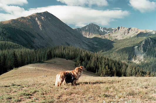
Click on photo to begin a deep venture into the valley and up to a snow cornice
by 12703' (3872 meter) Bills Peak in the distance. The shadowed mountain is the
west side of 12,804' (3903 meter) Byers Peak, near Fraser and Winter Park,
Colorado -- 40 minutes from Grand Lake.
The switchback road up to near Bottle Pass is no longer open to vehicles.
You need to park at the bottom. You could consider using a mountain bike
for the ascent and using it to coast back down to your vehicle.
It used to be ... that one could be in the setting shown above with just 15 minutes of
easy walking and 15 minutes of driving in an regular vehicle from Fraser. However,
even back then, the trail was HIDDEN. Below are the directions as we originally
posted them. When we revisit this splendid area, we will give new directions ...
Below are the old directions ... for historical purposes ...
To get here, go to the Byers Peak Trail Head (see below) and
then backtrack about 4/10th mile (2/3 kilometer) and park your car near some colored
ribbons you might spot on the tree branches. The trail you want does not go to the
weather station. Instead, it is a bit to your left (south). It parallels the road for a short
distance and then makes an easy ascent to the south facing tundra shown here. If you
turned around, you would see the tundra gently rising to Bottle Peak, Bottle Pass and
11,773' (3588 meter) Ptarmigan Peak. The elevation here is just over 11,200' (3414
meters). There is a HIDDEN trail that gracefully descends into the remote valley and
then curves up to the right to the top of the ridge. Maps show the trail beginning in the
forest at the top of the nearby saddle. This is wrong. Instead, you walk about 100 yards
to the sign post and then turn 120º to your right. Walk about 100 yards NW to the forest
and try to find the trail. It is in excellent condition and worth finding. If you are short on
time, enjoy the Bottle Pass area right here.
To get to the Byers Peak Trail Head you head towards Byers Peak from Fraser, but again
the route is not well marked, if at all. From the center of Fraser, turn west at the intersection
(without a traffic light) and cross the train tracks. Go a few blocks, turn left and drive a
couple of blocks past the homes and suddenly you'll meet the road that will take you to
Byers Peak in the Experimental Forest. If you see a sign saying St. Louis Creek, you are
doing fine. If you happen to be on the Crooked Creek Road, you are too far to the North.
You'll miss Byers Peak but see other interesting terrain. 10 minutes (or more?) up the
St. Louis road there is a well marked turn to the right to get on a the road to the Byers Peak
Trail Head. The road at first seems to backtrack and then heads almost level in a westerly
direction. You'll then meet a gate where the road will climb very steeply to the trail head.
You don't need 4WD. However, the road is open only during the summer and early fall.
It is narrow and has blind curves. Climb until it ends. For a mountain top experience you
can take the Byers Peak Trail. To explore Bottle Pass or the hidden valley in this photo series,
backtrack 4/10th of a mile.
.. return to scenery list ..